
File:Canada Quebec relief location map-conic proj.jpg

Size of this preview: 538 × 599 pixels. Other resolutions: 216 × 240 pixels | 431 × 480 pixels | 690 × 768 pixels | 1,184 × 1,318 pixels.
Original file (1,184 × 1,318 pixels, file size: 394 KB, MIME type: image/jpeg)
Captions
Captions
Add a one-line explanation of what this file represents
Summary
[edit]| Camera location | | View this and other nearby images on: OpenStreetMap |
|---|
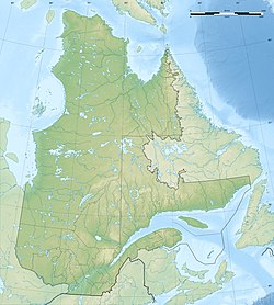
| Description |
Scale: 1:7,720,000 (precision: 1,930 m)
Geographic limits of the map:
|
||
| Date | |||
| Source |
Own work
|
||
| Creator | |||
| Permission (Reusing this file) |
|
||
| Georeferencing | If inappropriate please set warp_status = skip to hide. | ||
| Other versions |
|


Licensing
[edit]
I, the copyright holder of this work, hereby publish it under the following licenses:
This file is licensed under the Creative Commons Attribution-Share Alike 3.0 Unported license.
- You are free:
- to share – to copy, distribute and transmit the work
- to remix – to adapt the work
- Under the following conditions:
- attribution – You must give appropriate credit, provide a link to the license, and indicate if changes were made. You may do so in any reasonable manner, but not in any way that suggests the licensor endorses you or your use.
- share alike – If you remix, transform, or build upon the material, you must distribute your contributions under the same or compatible license as the original.

|
Permission is granted to copy, distribute and/or modify this document under the terms of the GNU Free Documentation License, Version 1.2 or any later version published by the Free Software Foundation; with no Invariant Sections, no Front-Cover Texts, and no Back-Cover Texts. A copy of the license is included in the section entitled GNU Free Documentation License. |
You may select the license of your choice.
File history
Click on a date/time to view the file as it appeared at that time.
| Date/Time | Thumbnail | Dimensions | User | Comment | |
|---|---|---|---|---|---|
| current | 12:21, 19 July 2010 | | 1,184 × 1,318 (394 KB) | Sting (talk | contribs) | Color profile |
| 17:38, 13 November 2009 |  | 1,184 × 1,318 (415 KB) | Sting (talk | contribs) | == {{int:filedesc}} == {{Location|53|58|30|N|68|25|30|W|scale:7000000}} <br/> {{Information |Description={{en|Blank physical map of the province of Quebec, Canada, for geo-location |
You cannot overwrite this file.
File usage on Commons
The following 6 pages use this file:
File usage on other wikis
The following other wikis use this file:
- Usage on ar.wikipedia.org
- Usage on de.wikipedia.org
- Magdalenen-Inseln
- Anticosti
- Mistassinisee
- Manicouagan-Stausee
- Caniapiscau-Stausee
- Gaspésie
- Pic Champlain
- Mont Babel
- Île Bonaventure
- Lac Saint-Jean
- Réservoir La Grande 3
- Gouin-Stausee
- Hochelaga-Archipel
- Lac Saint-Louis
- Lac des Deux Montagnes
- Île de Montréal
- Île d’Orléans
- Lac Saint-Pierre
- Mont Mégantic
- Lac Mégantic
- Lac Témiscouata
- Île Greenly
- Wikipedia:Kartenwerkstatt/Positionskarten/Nordamerika
- René-Levasseur-Insel
- Chaleur-Bucht
- Île de la Province
- Benutzer:Orci/Hilaire
- Île Sainte-Hélène
- Île Notre-Dame
- Isle des Allumettes
- Sendeturm Mont Royal
- Pingualuit-Krater
- Lac Minto
- Île Jésus
- Île Bizard
- Lac Wiyâshâkimî
- Parc national de la Gaspésie
- Mont Jacques-Cartier
- Parc national de Frontenac
- Parc national des Pingualuit
- Broadback Valley Forest
- Parc national du Mont-Tremblant
- Île des Sœurs
- Lac Tasiujaq
- Réservoir La Grande 4
- Lacs des Loups Marins
- Lac Matagami
- Lac D’Iberville
- Lac Bourdel
View more global usage of this file.