
File:Italy Trentino-South Tyrol relief location map.svg

Captions
Captions
Summary
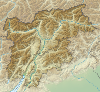
[edit]| Description |
Quadratische Plattkarte. Geographische Begrenzung der Karte:
Equirectangular projection. Geographic limits of the map:
|
||
| Date | |||
| Source |
Own work, using |
||
| Author | NordNordWest | ||
| Permission (Reusing this file) |
This file is licensed under the Creative Commons Attribution-Share Alike 3.0 Germany license.
 This file is licensed under the Creative Commons Attribution-Share Alike 3.0 Unported license.
|
||
| Other versions |
|
||
| SVG development |
|
.svg/120px-Flag_of_the_United_Kingdom_(3-5).svg.png)


File history
Click on a date/time to view the file as it appeared at that time.
| Date/Time | Thumbnail | Dimensions | User | Comment | |
|---|---|---|---|---|---|
| current | 19:38, 27 November 2013 | | 558 × 512 (865 KB) | NordNordWest (talk | contribs) | == {{int:filedesc}} == {{Information |Description= {{de|Positionskarte von Trentino-Südtirol, Italien}} Quadratische Plattkarte. Geographische Begrenzung der Karte: * N: 47.158416° N * S: 45.6061388° N * W... |
You cannot overwrite this file.
File usage on Commons
The following 2 pages use this file:
File usage on other wikis
The following other wikis use this file:
- Usage on ce.wikipedia.org
- Usage on de.wikipedia.org
- Usage on eo.wikipedia.org
- Montagne (Italio)
- Preore
- Ragoli
- San Michele all'Adige
- Katedralo de Sankta Vigilio
- Valo Noana
- Monto Pavione
- Ŝablono:Situo sur mapo Italio Trentino-Sudtirolo
- Kastelo Trauttmansdorff
- Kastelo Sigmundskron
- Marmolada
- Montpasejo Pordoi
- Gardena Valo
- Ulten-valo
- Nacia Parko Stelvio
- Adiĝa Valo
- Non-valo
- Universitato de Trento
- Tre Ville
- Borgo Lares
- Dimaro Folgarida
- Porte di Rendena
- San Lorenzo Dorsino
- Vallelaghi
- Madruzzo
- Terre d'Adige
- Valdaone
- Sella Giudicarie
- Altopiano della Vigolana
- Borgo Chiese
- Castel Ivano
- Contà
- Predaia
- Primiero San Martino di Castrozza
- Pieve di Bono-Prezzo
- Biotopo Lavini di Marco
- Usage on es.wikipedia.org
- Usage on frr.wikipedia.org
- Usage on fr.wikipedia.org
View more global usage of this file.